East Coast Greenway Alternate Route from New Haven to West Hartford CT
Updated maps in 2023
Bike tourists riding on the East Coast Greenway often contact us through Warmshowers to request to stay overnight at our home in West Hartford, located less than a mile from the route in Hartford. We enjoy hosting cyclists and sharing stories about travel on two wheels. But the current official ECG trail heading north from New Haven to Hartford sends riders on a long 54-mile route through Farmington, Avon, Simsbury, and Bloomfield, with a 1,915 foot total elevation gain. The most unpleasant portion of ECG section is Simsbury Road (aka Route 185), a busy road during rush hour with a narrow shoulder up a long hill, about a 350 foot gain over 1 mile. It’s not the best way to make cycling tourists feel welcome! Although there are future plans to re-route this portion of the ECG onto a bike trail, it’s still years away from completion.
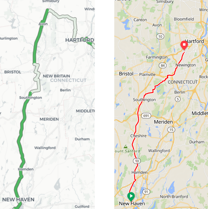
Instead, I recommend this 37-mile alternate bike route from north from New Haven thru New Britain to West Hartford on RideWithGPS, with a similar-but-not-identical version on Google Maps. This route follows about half of the official ECG route, then diverts through New Britain CT and the multi-use path toward West Hartford, for a much more pleasant and shorter ride, with total elevation gain of 1,400 feet, much less than the 54-mile route above. If you’re traveling in the opposite direction, see the same route headed south from West Hartford thru New Britain to New Haven on RideWithGPS
Here’s a brief summary 37-mile alternative route, heading north from New Haven to the Hartford area, with suggested stops along the way:
- From New Haven, follow the East Coast Greenway / Farmington Canal Trail north for about 23 miles. Look for food trucks on the left outside New Haven, and very nice outdoor bathrooms and water fountains in Cheshire and Southington.
- When the current ECG / Farmington Canal Bike Trail ends in Southington, follow the on-road directions (from ECG or Google Maps) for about 2.5 miles: right on Curtiss St, left on Main St (Route 10), right on Flanders St, left on Flanders Rd. (Was the person who lived at this intersection named Flanders?)
- Instead of following ECG directions to continue straight on Flanders Rd, turn right onto Mine Hollow Road. This is one steep uphill climb (about 200 feet over 0.7 miles), but it’s a quiet farm road, and better than the Simsbury Road - Route 185 option on the official ECG route above. At the top of the hill, turn left onto Long Bottom Road and check out the Rogers Orchards apple farmstand and bakery on the left, a nice rest stop when it’s open. If you need a restroom, ask them to point you to it, up the stairs and in a building next door.
- Take a right on Reservoir Road / North Shuttle Road for a beautiful ride around the reservoir, then Walnut Hill Park and the New Britain Museum of American Art, before arriving in downtown New Britain.
- In downtown New Britain, turn right into the CT fastrak bus station and follow the protected Multi-Use Trail that generally runs alongside the dedicated bus route. Note that when you cross East Street - Route 175, the protected trail looks like a sidewalk for a half mile, then turn right into the next CT Fastrak bus station to pick up the Trail again. Excluding this half-mile interruption, the protected Multi-Use Trail runs for almost 8 miles from New Britain to Newington.
- When the Multi-Use Trail ends near the Newington Junction Station, take a right onto West Hill Road, then a quick left onto Willard Road, which continues and becomes Newington Road, heading to West Hartford. While this road is busy during rush hour, it has a wide shoulder and is flat.
- When Newington Road ends, one option is to go straight through the intersection onto the sidewalk entrance into the Elmwood Community Center, where in the back parking lot you can access the Trout Brook Trail. Another option is to turn left onto New Britain Ave for 100 feet, then make a quick right onto Quaker Lane.